
The Indian Meteorological Department said that a low-pressure system over the south of Bay of Bengal is to be expected to turn into a cyclonic storm. The system is expected to grow in the southeast of Sri Lanka and it may change into despair in the coming next 36 hours. If it turns into a cyclone then there is a probability that it can cause destruction on the coast of Tamil Nadu, the agency further added.
HIGHLIGHTS
- Cyclone Fani has intensified into a severe cyclonic storm with chances of more severity
- Navy has been put on high alert with ships stationed on Vishakhapatnam and Chennai coasts
- NDRF and Coast Guard has also been put on high alert
- IMD says Fani may hit Kerala coast on Saturday
- Fishing in the coastal regions is banned till May 1
- Last year cyclone Ockhi had hit India and Sri Lanka, causing many casualties
- Cyclone Fani is moving northwestward at a speed of 16 km per hour
- It could strengthen into the “very severe” category in the next 24 hours
- There is “little chance” of “Fani” crossing Tamil Nadu coast, say Experts
- Help and information: Odisha’s emergency helpline number +916742534177
Weather forecast today, Cyclone Fani LIVE News Updates: Many Areas In Puri And Other Places Submerged
- May 03, 11:09 AM (IST)
JUST IN: One person died due to the uprooting of trees in Sakhigopal area of Puri due to strong winds. Rainfall under the impact of Fani is around 150 mm in affected areas. (News18)
- May 03, 11:02 AM (IST)
All flights cancelled in Kolkata Airport due to Cyclone Fani
Airport authorities have asked airlines to cancel domestic and international flights from 3:00 pm on May 3 to 8:30 am on May 4 due to cyclone Fani from the Kolkata Airport. Engineers and other emergency systems are on standby at the airport. While in Tripura, as of now there has been no impact of cyclone Fani to Agartala Airport and all flights are on schedule. (News18)

- May 03, 10:49 AM (IST)
UPDATE: The extremely severe cyclonic storm Fani lay centered at 9:30 am near Lat. 19.80N and Long. 85.70E over Odisha coast close to Puri. The latest obversation indicates that the eye of the system has completely moved into land by 10:00 am, said IMD.
- May 03, 10:42 AM (IST)
Mamata Banerjee to stay in Kharagpur and monitor situation
West Bengal CM Mamata Banerjee to stay in Kharagpur, near the coastal belt and monitor the situation herself, today and tomorrow. All her political campaigns for the two days have been cancelled.
- May 03, 10:40 AM (IST)

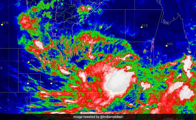
#CycloneFani 10:00 Hr radar image update by IMD. The centre or “eye” of the cyclone has moved northeastwards in the last 1 hr.
- May 03, 10:34 AM (IST)

Odisha: Heavy rainfall and strong winds hit Ganjam as #FANI cyclone hits Puri coast with wind speed of above 175km/per hour.
- May 03, 10:34 AM (IST)
Winds in Puri, Odisha are blowing at a maximum speed of 240-245 km per hour and heavy to very heavy rains are continuing over the Odisha coast. After landfall, the impact is likely to reduce and it is likely to move towards West Bengal coast.
- May 03, 10:25 AM (IST)
UPDATE: 13 Navy aircraft are at standby in Visakhapatnam to carry out damage assessment and relief distribution requirements.
- May 03, 10:16 AM (IST)
JUST IN | The Indian Metereological Department (IMD) confirmed that landfall process caused by the cyclone in Puri is complete. Strong winds over Puri are expected to continue over the next three hours.
- May 03, 10:09 AM (IST)
Wind speed of 35 km/hr recorded at 9 AM: IMD
Landfall process started around 8 AM and is expected to complete within 2 hours. It is then expected to move north-northeastwards, covering all districts in coastal Odisha, towards West Bengal. Wind speed of 35 km/hr recorded in latest updates at 9 AM and it will increase, said R Shukla, IMD Paradip, Odisha.


Rescue teams, which comprise personnel from the NDRF and SDRF, would be deployed in vulnerable areas in the south, R Satyagopal, Commissioner of Revenue Administration, said. As many as 4,339 vulnerable areas have been mapped, providing data like relief centres and evacuation routes for use by inter-departmental teams to take appropriate steps, he said.
The District Collectors have been asked to keep relief centres in coastal areas ready. Also, the inter-departmental zonal teams have been advised to be ready for deployment, he added.
The tropical depression is going to move forward to the northeast after it reaches Tamil Nadu on Monday and is going to carry on on the similar path up till Tuesday. From Wednesday to Friday, the path of the depression may possibly change to some extent in the north-northeastward course along the coastline of Andhra Pradesh, as per to the Met department.
Here are the highlights on cyclone warning in Bay of Bengal:
The statement released by Indian Meteorological Department stated, “The low pressure area over east Equatorial Indian Ocean and adjoining southeast Bay of Bengal lies as a well marked low pressure area over the same region. It is very likely to intensify into a depression during the next 36 hours over east Equatorial Indian Ocean and adjoining central parts of south of Bay of Bengal. It is very likely to intensify into a cyclonic storm subsequently.”
A tweet from the Chief Minister’s Office has tweeted, “Fishermen are advised not to venture into these areas. Fishermen at deep sea were advised to return to respective coasts by 12 am of 26th April 2019. The fishing villages are being informed to take necessary precautions.”
CYLONE FANI: It is cyclone now, IMD will announce soon.
Thing is how close it can come near Northern TN coast especially Chennai, Kanchipuram, Tiruvallur. Rain depends on how close the recurve starts.
Location: 4.5°N 87.9°E
Max Winds: 35 kt (64kmph)1002 mb
#Cyclonefani pic.twitter.com/sHk7FQmqhP— Rainstorm (@RainStorm_TN) April 27, 2019
As the water levels may possibly rise, the people have also been advised not to cross rivers.
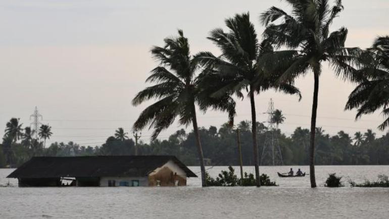
There is a probability of heavy rainfall in several parts of Kerala on April 29, 30 and May 1.
The system may possibly hit the Tamil Nadu coast on April 30 and can lead to a heavy rain in Kerala as well as Karnataka.
The statement released by Kerala State Disaster Management Authority stated, “On April 29, 30 and May 1, the possibility of severe rainfall in many parts of Kerala has been predicted. Strong winds (from 30-40 km/hour and gusting upto 50 km /hour) are expected in Kerala from 26-4-2019.”
Cyclone Fani: Deep depression to intensify in next 12 hours as Tamil Nadu braces for the storm
As per to the state body, a yellow alert (be watchful) has been issued in the districts of Ernakulam, Idukki, Thrissur and Malappuram for April 29.
People who lives in the coastal areas as well as low lying areas, have been asked to keep their documents in simply easily reached place as well as the emergency kits ready after Cyclone Fani warning.
People in Kerala have been warned to avoid night travels in the middle of 7pm to 7am to hilly lands and districts like Ernakulam, Idukki, Pathanamthitta, Thrissur, Malappuram, Wayanad, Kottayam, Kozhikode and Palakkad districts, the place where the possibility of landslides are common.
The Kerala State Disaster Management Authority – the nodal agency for the duration of natural disasters in the state has released an alert to fishermen not to undertaking into the Indian Ocean, in the southeast and neighbouring regions of Bay of Bengal as well as the Tamil Nadu seashore.


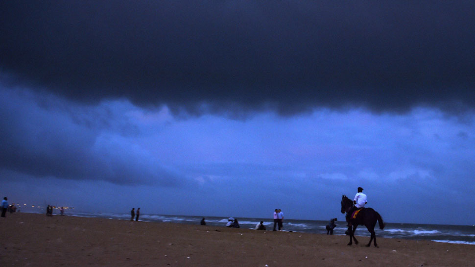
Cyclone warning in a coastal region, heat wave in central, north India
Welcome to the Indian Express blog on weather updates for today. The coastal region of Andhra Pradesh, Puducherry and Tamil Nadu are faced with an imminent cyclone in the coming week. Meanwhile, in the North and Central region, a strong heat wave is likely to prevail.